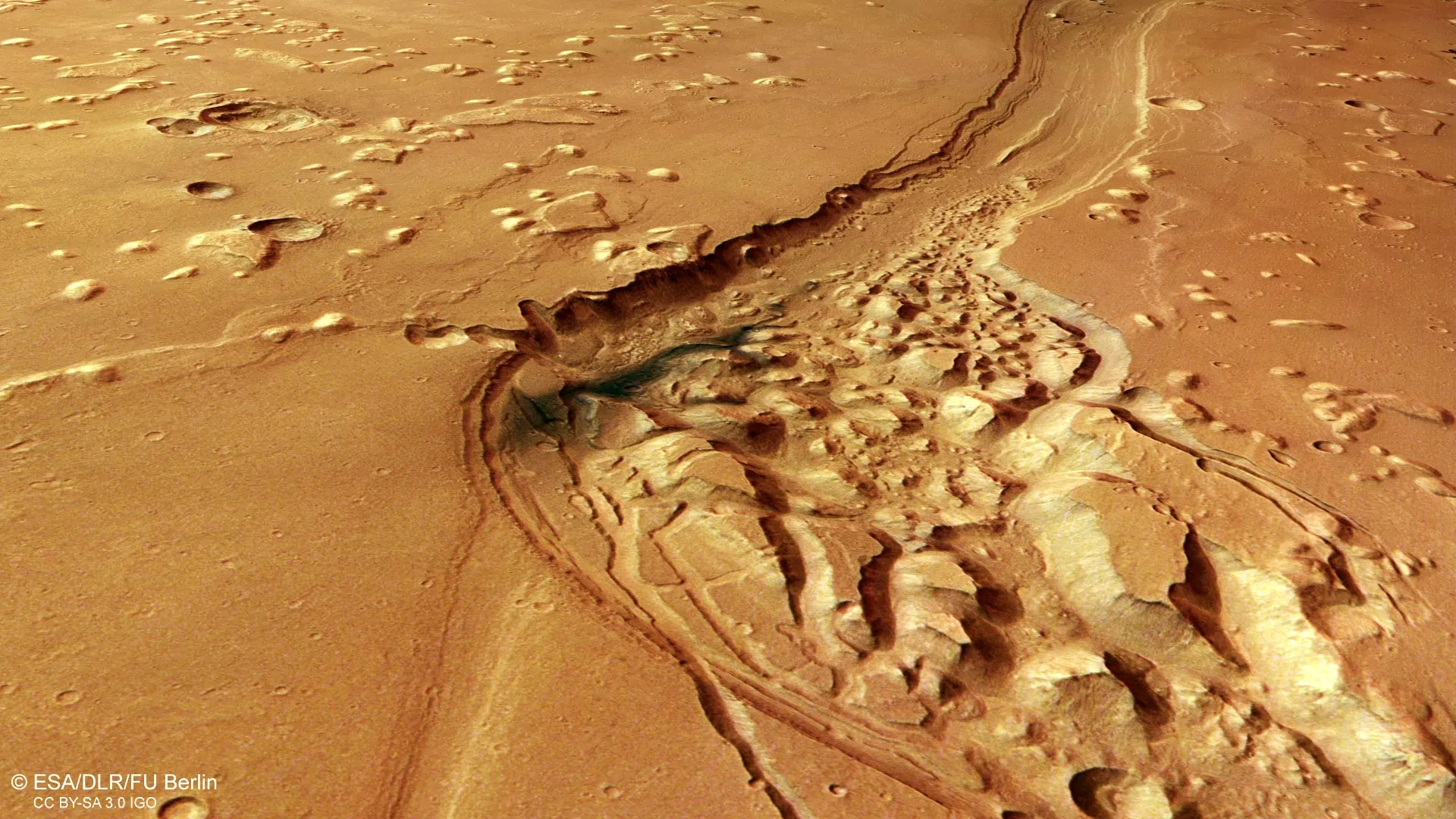
Shalbatana Vallis, a 1,300-kilometer scar stretching across Mars near the planet's equator, tells a story written in water, lava, and time. This enormous valley—roughly the length of Italy—bears the marks of ancient floods that tore through the Martian landscape 3.5 billion years ago, carving channels 500 meters deep as vast amounts of groundwater burst onto the surface in a catastrophic release of pressure from below.
For more than two decades, the European Space Agency's Mars Express spacecraft has been scrutinizing the Red Planet, and this month its High Resolution Stereo Camera (HRSC) is spotlighting this remarkable valley in unprecedented detail. What makes Shalbatana Vallis so compelling is not just what it reveals about Mars's ancient hydrology, but what it suggests about the planet's past habitability. The valley flows from the highlands of Xanthe Terra downward toward Chryse Planitia, one of the lowest regions on Mars, where many of the planet's major outflow channels converge. Scientists believe this low-lying basin may once have contained a vast ocean during a warmer, wetter period in Martian history.
The valley itself measures roughly 10 kilometers wide, and the latest imagery from Mars Express reveals layers of geological complexity that tell of multiple planetary forces at work. Among the most striking features are patches of blue-black material believed to be volcanic ash, later redistributed by winds across billions of years. Scattered throughout the region are impact craters—some sharp and recent-looking, others partially buried or eroded, their ejecta blankets still visible as debris fields blasted outward during the original collisions. Some terrain bears the smooth, crumpled appearance of ancient lava flows that cooled and contracted, forming what geologists call wrinkle ridges. Isolated hills called mesas stand as remnants of older, elevated surfaces that have slowly eroded away.
What catches the eye most vividly, though, is the chaotic terrain that appears throughout the valley—landscapes filled with broken blocks, irregular ridges, and tumbled mounds of rock. Scientists believe this distinctive topography formed when underground ice melted away billions of years ago. As the frozen water disappeared, the ground above it shifted and collapsed, creating the fractured appearance we see today. Similar chaotic landscapes have been spotted elsewhere on Mars: in Pyrrhae Regio, Iani Chaos, Ariadnes Colles, Aram Chaos, and Hydraotes Chaos. Each one is a puzzle piece in the larger picture of a planet that was once far more geologically active and hydrologically dynamic than it appears today.
The evidence layered throughout Shalbatana Vallis—the outflow channels, the collapsed terrain, the volcanic deposits, the impact scars—combines to paint a portrait of extraordinary planetary change. Researchers believe the valley may have been even deeper in its earliest days, gradually filled by sediment and volcanic material over billions of years. It is a record not just of water's power to reshape landscapes, but of Mars's transformation from a potentially habitable world to the cold, dry planet we observe today. As Mars Express continues its mission from orbit, it keeps adding detail to this ancient story, one camera frame at a time.