Deep beneath the Grand Canyon's layered red rocks, a hidden infrastructure of caves and underground passages is keeping one of Earth's most iconic landscapes alive—and scientists are finally mapping it in three dimensions.
Every day, millions of visitors to Grand Canyon National Park rely on water from a single source: Roaring Springs, a cave-fed spring on the North Rim that is so remote there is no trail leading directly to it. The spring supplies water not only to hikers trekking through extreme heat but also to the plants, animals, and entire ecosystems that depend on it. As the region becomes hotter and drier, understanding how this vital water system works has become urgent.
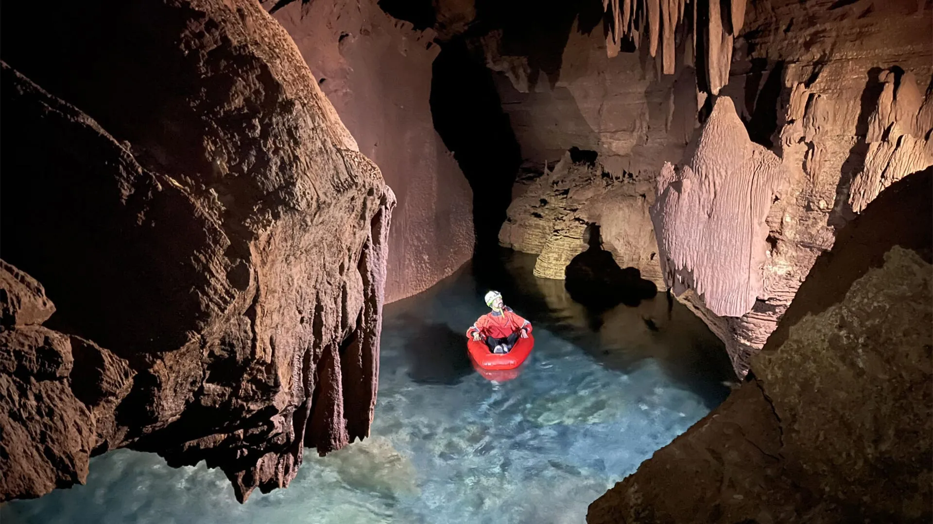
Researchers at Northern Arizona University, led by professor Temuulen "Teki" Sankey and Ph.D. student Blase LaSala, are solving this mystery using a technology more often associated with self-driving cars: mobile lidar scanning. Over 45 days of fieldwork, the team and volunteers carried lidar equipment in packs weighing up to 55 pounds through remote cave entrances—some taking two days of hiking to reach. Once inside, they climbed, rappelled, crawled, and even floated through flooded passages to map the underground landscape. The result was the first-ever high-resolution 3D documentation of more than 10 kilometers of underground passages and chambers. "I had no idea how large and long these caves are," Sankey said. "Grand Canyon's caves have never been mapped in 3D like this."
The geometric details revealed by these maps are far more than academic curiosities. Cave formations follow recognizable geological patterns—the arrangement of passages, cracks, and openings acts like a blueprint showing how water travels through different layers of rock beneath the canyon. The cave-fed springs emerge from deep within Redwall and Muav limestone formations, with several rock layers sitting between those springs and the surface high above on the Kaibab Plateau.
The most likely source is snowmelt from that plateau, but the journey underground has remained largely mysterious—until now. Previous dye tracing experiments conducted by the park revealed something surprising: water can move extraordinarily fast through this underground system. In some tests, dye poured into sinkholes on the plateau traveled roughly 20 kilometers and appeared at springs in as little as a week. The exact pathways remain uncertain, influenced by fractures, faults, rock permeability, and countless underground channels. As LaSala puts it: "It's like looking at a black box. You see what comes in and what comes out, but it's very hard to quantify what's going on in there."
With the new 3D maps, that black box is becoming transparent. The research, published recently in Scientific Reports and supported by a grant from Grand Canyon National Park, opens a window into an ecosystem that has sustained life in one of Earth's driest places for millennia. Understanding these connections isn't just about satisfying scientific curiosity—it matters for water quality, public safety, and the survival of species that depend on springs like Roaring Springs. In an era of climate change, knowing how water moves through the Grand Canyon's hidden arteries could be the key to preserving what lies above.